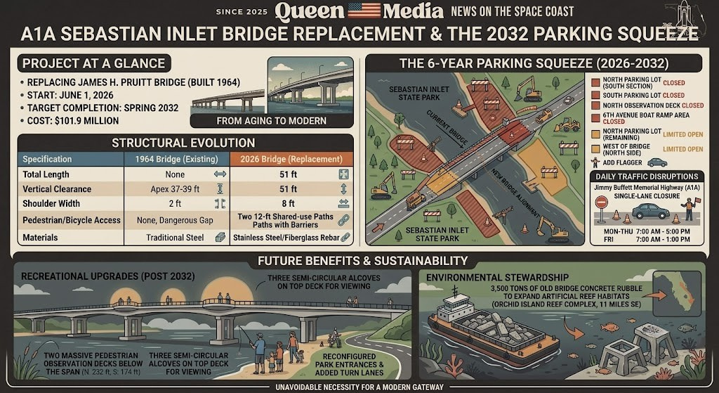
The A1A Sebastian Inlet Bridge Replacement and the 2032 Parking Squeeze
Please note that this illustration is for conceptual purposes only and does not represent an exact, real-world depiction.
The Space Coast is on the precipice of a generational infrastructure transformation. On June 1, 2026, the Florida Department of Transportation (FDOT) commenced a $101.9 million replacement of the State Road A1A bridge over the Sebastian Inlet. Designed to rectify critical structural deficiencies while modernizing the corridor for pedestrians, cyclists, and the region's robust angling community, the project represents a massive leap forward for the region's infrastructure. However, constructing a towering new span across a dynamic tidal inlet is a complex undertaking. Slated to continue through the spring of 2032, this six year endeavor ushers in an extended era of logistical hurdles. For the hundreds of thousands of locals and tourists who frequent the Sebastian Inlet State Park, the most immediate and enduring impact will be the severe restriction of parking availability and park access.
Historical Context and the Mandate for Modernization
The existing James H. Pruitt Memorial Bridge, completed by Cleary Brothers Construction Company in 1964, has served as a vital regional artery connecting Brevard and Indian River counties for over six decades. The bridge's inception was a political and engineering triumph spearheaded by State Representative James H. Pruitt, who successfully orchestrated the relocation of the Brevard Indian River county line to the center of the inlet to secure inter county funding. Upon its dedication in 1965, the structure transformed the inlet from a remote, difficult to access locale into a premier Florida destination. Today, the inlet supports an annual economic value exceeding $200 million, driven by tourism, world class surfing, and fishing, drawing more than 819,000 visitors in 2021 alone.
Despite its historical significance and status as a high integrity embodiment of mid century prestressed concrete engineering, the bridge has reached the end of its service life. The original anchor cantilever design featuring rigid frame concrete bents driven into the underlying coquina rock has suffered from decades of harsh saltwater exposure, tidal scouring, and extreme weather. Following Hurricane Florence in 2018, FDOT classified the structure as structurally deficient, functionally obsolete, and scour critical, assigning it a sufficiency rating of just 51.6 out of 100. Because severe corrosion rendered further rehabilitation impractical, state policy mandated a total replacement.
The new bridge, being constructed slightly east of the current alignment by contractor Webber, LLC, is engineered to meet modern structural standards. The table below highlights the structural evolution from the mid century span to the modern replacement.

The Six Year Parking Squeeze (2026 2032)
While the long term benefits of the new span are universally acknowledged, the realities of staging a massive construction zone within an active, 4(f) protected state park require substantial logistical sacrifices. FDOT has acquired approximately 3.46 acres of park property to meet current design standards for right of way, stormwater management, and staging. Consequently, the footprint required for cranes, trestles, and heavy machinery will severely curtail parking capacity through 2032.
Beginning June 1, 2026, visitors face a labyrinth of cordoned off zones, repurposed lots, and changing access points. These partial closures operate around the clock to safely facilitate bridge construction, the erection of permanent retaining walls, and drainage system overhauls.
The following table outlines the specific parking and access modifications that will remain in effect until the project's estimated completion in the spring of 2032:
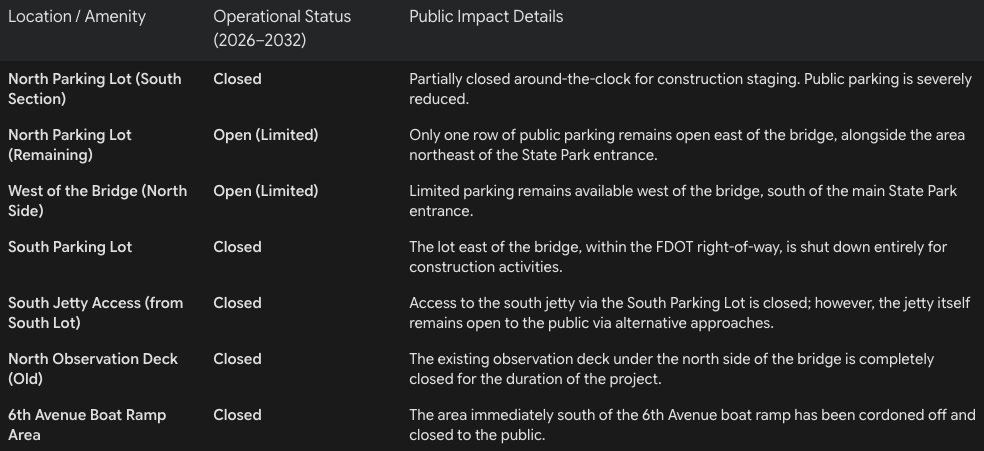
These reductions dictate a fundamental shift in how residents and tourists will utilize the inlet. During peak weekend hours, summer holidays, and major surfing competitions, parking capacity will likely be exhausted rapidly. Visitors are advised to carpool, utilize off peak hours, or seek alternative beach access along the A1A corridor to mitigate the frustration of arriving at a full capacity state park.
Navigating Traffic Operations and Concurrent Construction
Beyond the parking constraints, the flow of vehicular traffic along the Jimmy Buffett Memorial Highway will experience daily disruptions. To honor a commitment established during the project's initial study phase, FDOT has ensured that no total bridge closures or lengthy detours will be implemented. Two way traffic will be maintained across the inlet, but motorists must brace for persistent single lane closures.
These temporary lane closures are permitted daily from Monday through Thursday between 7:00 a.m. and 5:00 p.m., and on Fridays from 7:00 a.m. to 1:00 p.m.. Flag operators will manage the alternating flow of vehicles, creating a traffic rhythm familiar to barrier island residents who endured similar long term disruptions during the 17th Street Bridge repairs in Vero Beach.
The traffic impacts of the Sebastian Inlet project are compounded by a broader regional infrastructure overhaul. FDOT is simultaneously widening a one mile stretch of State Road 510 from two lanes to four between 85th Street and County Road 512, a $24.9 million endeavor expected to last through the fall of 2028. Furthermore, a $9.2 million resurfacing project for a four mile stretch of U.S. 1 is scheduled to commence in the spring of 2027. The overlapping timelines of these projects mean that north island residents and commuters will face continuous, multi front construction zones for years.
To partially alleviate long term traffic friction at the park itself, the new bridge project incorporates permanent roadway enhancements. The design includes the reconfiguration of both the north and south state park entrances, adding exiting right turn lanes to improve traffic operations. Additionally, FDOT is constructing a new southbound acceleration lane out of the south entrance and lengthening the southbound right turn storage lanes into both sides of the park, ensuring smoother ingress and egress once the project concludes.
Environmental Stewardship and Recreational Upgrades
While surface level construction dominates the roadway, the dynamic marine environment below is also highly active. The Sebastian Inlet District (SID), chartered in 1919, must maintain the inlet's 150 foot wide navigational channel at a depth of 10.5 feet, alongside a 17 foot deep sand trap. Concurrent with the bridge project, SID dredging contractors, such as ATL Diversified Inc., operate heavy machinery to pump sand through pipes that snake directly under the A1A bridge, bypassing sand to the downdrift beaches to mitigate coastal erosion. FDOT and SID are coordinating to ensure marine traffic through the inlet is maintained, with ample advance notice provided for any brief, safety related navigational restrictions.
The completion of the bridge in 2032 promises a vastly superior recreational landscape. The state has carefully integrated the cultural identity of the Sebastian Inlet into the engineering blueprints. The new structure will boast two massive, pedestrian only observation decks extending directly beneath the span. The north deck will stretch 232 feet over the water, while the south deck will extend 174 feet. These expansive platforms will replace the antiquated catwalks, offering safe, dedicated spaces for anglers away from the hazards of roadway traffic and speeding cyclists. Furthermore, the top deck of the bridge will feature three semi circular alcoves on each side, allowing pedestrians to step out of the shared use paths to safely observe marine life and ocean views out of the flow of active traffic.
The environmental forethought of the project extends to the disposal of the original 1964 structure. Rather than discarding the old bridge into a landfill, 3,500 tons of the concrete rubble will be loaded onto barges and transported to the Orchid Island Reef complex. This initiative, partially funded by a $110,000 contribution from the Coastal Conservation Association, will utilize the remains of the old bridge to expand artificial reef habitats 11 miles southeast of the inlet, bolstering local marine biodiversity and establishing new offshore fishing grounds.
The State Road A1A Sebastian Inlet Bridge replacement is an unavoidable necessity, driven by the relentless forces of nature and the aging limits of mid century infrastructure. For the next six years, navigating the Space Coast's most famous inlet will require strategic planning to overcome parking shortages, a tolerance for lane closures, and an abundance of patience. As heavy machinery dominates the skyline and the familiar parking lots serve as staging grounds for steel and concrete, the temporary pains of construction are paving the way for a modern, multi modal gateway that ensures the Sebastian Inlet remains a safe and thriving economic engine through the 21st century.